Spacecraft photos reveal an ancient, dried-up river system on Mars that stretches 435 MILES across the surface and could be 3.5 BILLION to 4 BILLION years old

The European Space Agency (ESA) has released pictures of an ancient, dried-up river system that stretches out for nearly 700 kilometres across the surface of Mars, which is surprisingly earth-like in appearance. The valley stream, which is named Nirgal Vallis, is said to have been shaped by flowing water and impacts. By exploring the characteristics of the surrounding craters, the European Space Agency has estimated the system’s age to be between 3.5 and 4 billion years old.
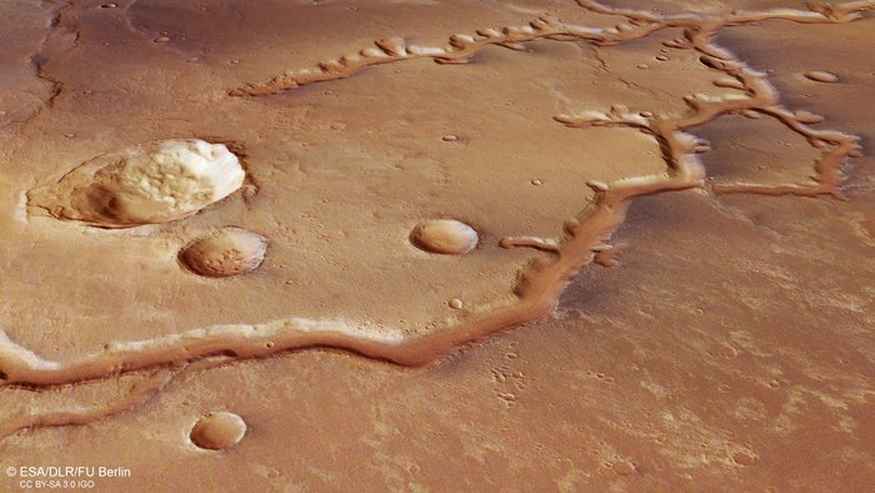
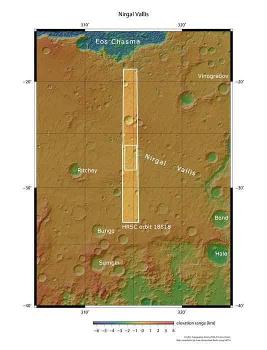
This image from ESA’s Mars Express shows a dried-up river valley on Mars named Nirgal Vallis. This oblique perspective view was generated using a digital terrain model and Mars Express data gathered on 16 November 2018 during Mars Express orbit 18818. The ground resolution is approximately 14 m/pixel and the images are centred at about 315°E/27°S. This image was created using data from the nadir and colour channels of the High Resolution Stereo Camera. The nadir channel is aligned perpendicular to the surface of Mars, as if looking straight down at the surface.
According to the announcement by European Space Agency (ESA), the area of Mars shown in these new images from ESA’s Mars Express spacecraft lies just south of the planet’s equator, and is known to have been shaped by a mix of flowing water and impacts: events where rocks sped inwards from space to collide with the martian surface.
Both of these mechanisms are visible here: a number of impact craters, some large and some small, can be seen speckled across the ochre, caramel-hued surface, and a tree-like, forked channel cuts prominently through the centre of the frame.
This ancient valley system is named Nirgal Vallis, and was once filled with running water that spread across Mars. By exploring the characteristics of the surrounding craters, scientists estimate the system’s age to be between 3.5 and 4 billion years old.

The part of Nirgal Vallis captured in these images lies towards the western end of the river system, where it is slowly spreading out and dissipating; the eastern end is far less branched and more clearly defined as a single valley, and opens out into the large Uzboi Vallis – the suspected location of a large, ancient lake that has long since dried up.
Nirgal Vallis is a typical example of a feature known as an amphitheatre-headed valley. As the name suggests, rather than ending bluntly or sharply, the ends of these tributaries have the characteristic semi-circular, rounded shape of an Ancient Greek amphitheatre. Such valleys also typically have steep walls, smooth floors, and, if sliced through at a cross-section, adopt a ‘U’ shape. The valleys pictured here are about 200 m deep and 2 km wide, and their floors are covered in sandy dunes; the appearance of these dunes indicates that martian winds tend to blow roughly parallel to the valley walls.

